Publicado el 28/03/2019
Ucayali. El pasado 15 de marzo del presente año, se iniciaron los trabajos de campo para elaborar el levantamiento del Plan Conjunto del Territorio, es decir, el área demarcada que se titulará a favor de la Comunidad Campesina Ribereña Guapries del Río Alto Callería, ubicada en el distrito de Callería, provincia de Coronel Portillo, región Ucayali. La actividad consistió en incorporar el nombre de las quebradas identificadas y reconocidas por los propios comuneros de Guapries, ubicados en el territorio.

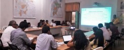
Representante de la DRA Ucayali, explicando en anexo Nueva Esperanza (Guapries)
Los trabajos en campo y el ingreso a la zona fueron notificados a través de medios de circulación regional y nacional, según la Ley N° 24657 que declara de necesidad nacional e interés social el deslinde y titulación del territorio de las comunidades campesinas. Estuvieron presentes comuneros miembros de Guapries, los colindantes al Parque Nacional Sierra del Divisor, representados por el Servicio Nacional de Áreas Naturales Protegidas por el Estado (SERNANP) y los del Bosque de Producción Permanente (BPP), en representación del Servicio Forestal y de Fauna Silvestre (SERFOR).
Durante la ejecución de los trabajos se realizaron asambleas generales en los anexos Guacamayo y Nueva Esperanza, pertenecientes a Guapries, para dar a conocer el inicio del proceso de titulación, los pasos a seguir y las actividades a realizar.

Representante de la DRA Ucayali explicando los detalles del trabajo.
Luego de este proceso, la Dirección de Saneamiento Físico Legal de la Dirección Regional Agraria (DRA) de Ucayali procesará toda la información recogida hasta generar el Plano Conjunto del Territorio y la memoria descriptiva, que junto a las actas de colindancia; constituirán los títulos definitivos de propiedad de la comunidad sobre su territorio. Esta actividad se realiza en el marco del convenio suscrito entre la DRA de Ucayali y el Centro para el Desarrollo del Indígena Amazónico (CEDIA).